 | [Espanha e Portugal]
 / [editado por Eduard Jul'evic Petri, Julij Michajlovic Sokal'skij] . - S. Petersburgo: [A.F. Marx], 1904 . - 1 mapa | Petri, Eduard J., 1854-1899, ed. lit.; Sokal'skij, Julij Michajlovic, ed. lit.; Marx, A. F., 1838-1904, ed. com. | Entidade: UC | Ver na fonte | Cópia digital | Link persistente deste registo: http://id.bnportugal.gov.pt/bib/rnod/319132 |
|  |
 | Chias y Carbó, Benito, fl. 1900-1938?, cartogr., e outro(s)
| Algarve / Benito Chias Ingº.; Jqn. Ribera Dº.; J. Soler Gº . - Barcelona: Alberto Martin, [ca. 19--?] . - 1 mapa | Chias y Carbó, Benito, fl. 1900-1938?, cartogr.; Ribera, Joaquin, cartogr.; Soler, J., grav. aguaf. | Entidade: UC | Ver na fonte | Cópia digital | Link persistente deste registo: http://id.bnportugal.gov.pt/bib/rnod/319133 |
| |
 | | |
 | Waghenaer, Lucas Janszoon, ca. 1533-1606, cartogr., e outro(s)
| Die Zee carte van Portugal, tusschen Camino en Montego, alfoe dat landt all daer in Sijn ghedaente is, met alle Sijne haeuen enn ondiepten, met groeter naersticheijt en vliedt ghecorrigeevt = : Ora maritima Portugallia inter Caminum et Montegum, quemadmodum Regio illa in sua stat figura cum omnibus suis portubus, atge vadis sumo studio a Iuca Ioannis aurigarto descriptio / Ioannes a Doetecum Fecit . - [Amsterdam]: [Cornelis Claesz], [1590] . - 1 mapa | Waghenaer, Lucas Janszoon, ca. 1533-1606, cartogr.; Doetichum, Jan van, fl. 1592-m. 1630, grav. aguaf.; Claesz, Cornelis Nicolas, ca. 1546-1609, livreiro | Entidade: UC | Ver na fonte | Cópia digital | Link persistente deste registo: http://id.bnportugal.gov.pt/bib/rnod/319135 |
| |
 | | |
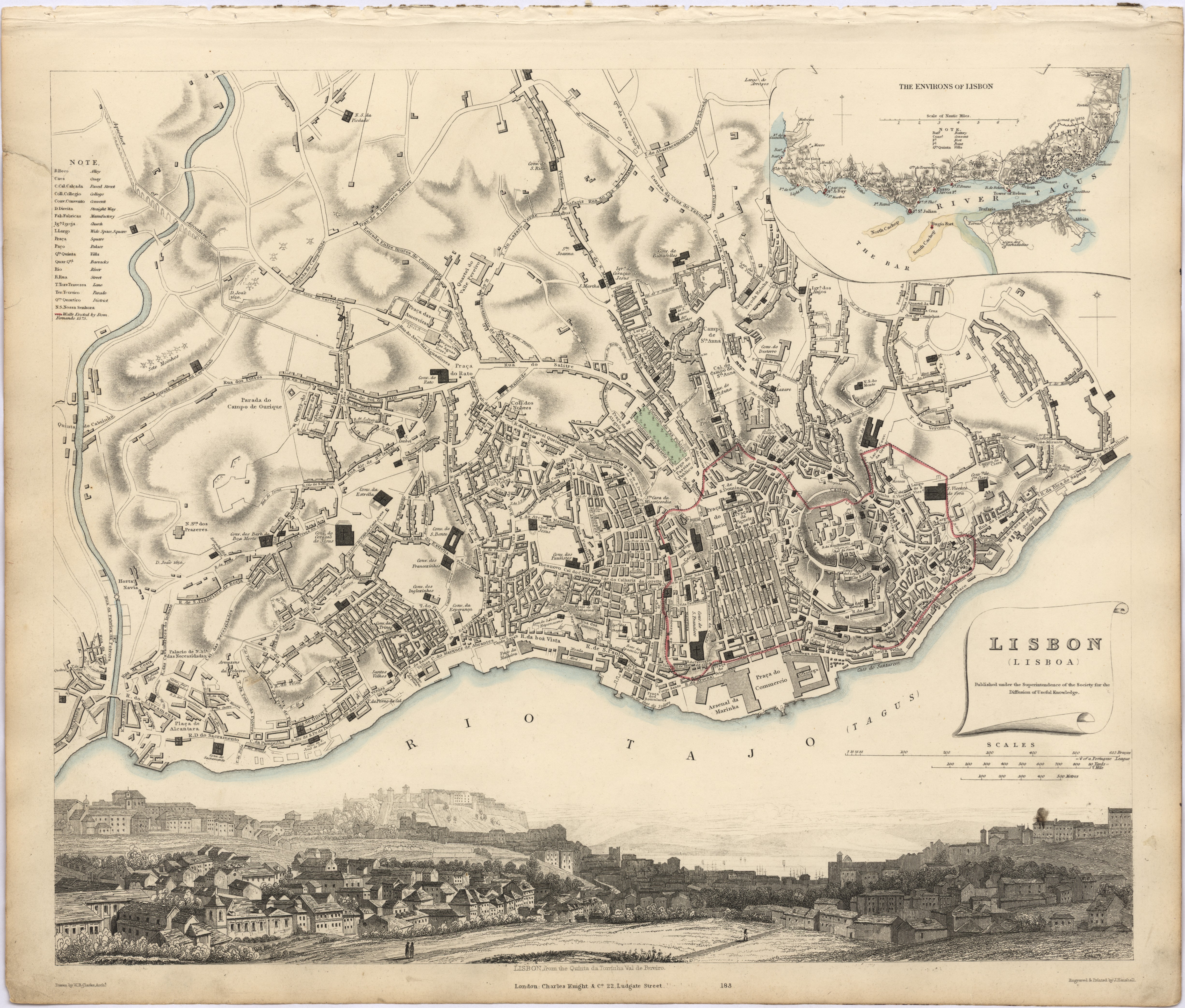 | Clarck, W. D., c. 1840, cartogr., e outro(s)
| Lisbon = : Lisboa / published under the superintendence of the Society for the Diffusion of Useful Knowledge; engraved & printed by J. Henshall; drawn by. W. B. Clarck . - [London]: Charles Knight, ca. 1852 . - 1 mapa | Clarck, W. D., c. 1840, cartogr.; Henshall, J., fl. 1833, grav. aguaf.; Society for the Diffusion of Useful Knowledge, | Entidade: UC | Ver na fonte | Cópia digital | Link persistente deste registo: http://id.bnportugal.gov.pt/bib/rnod/319137 |
| |
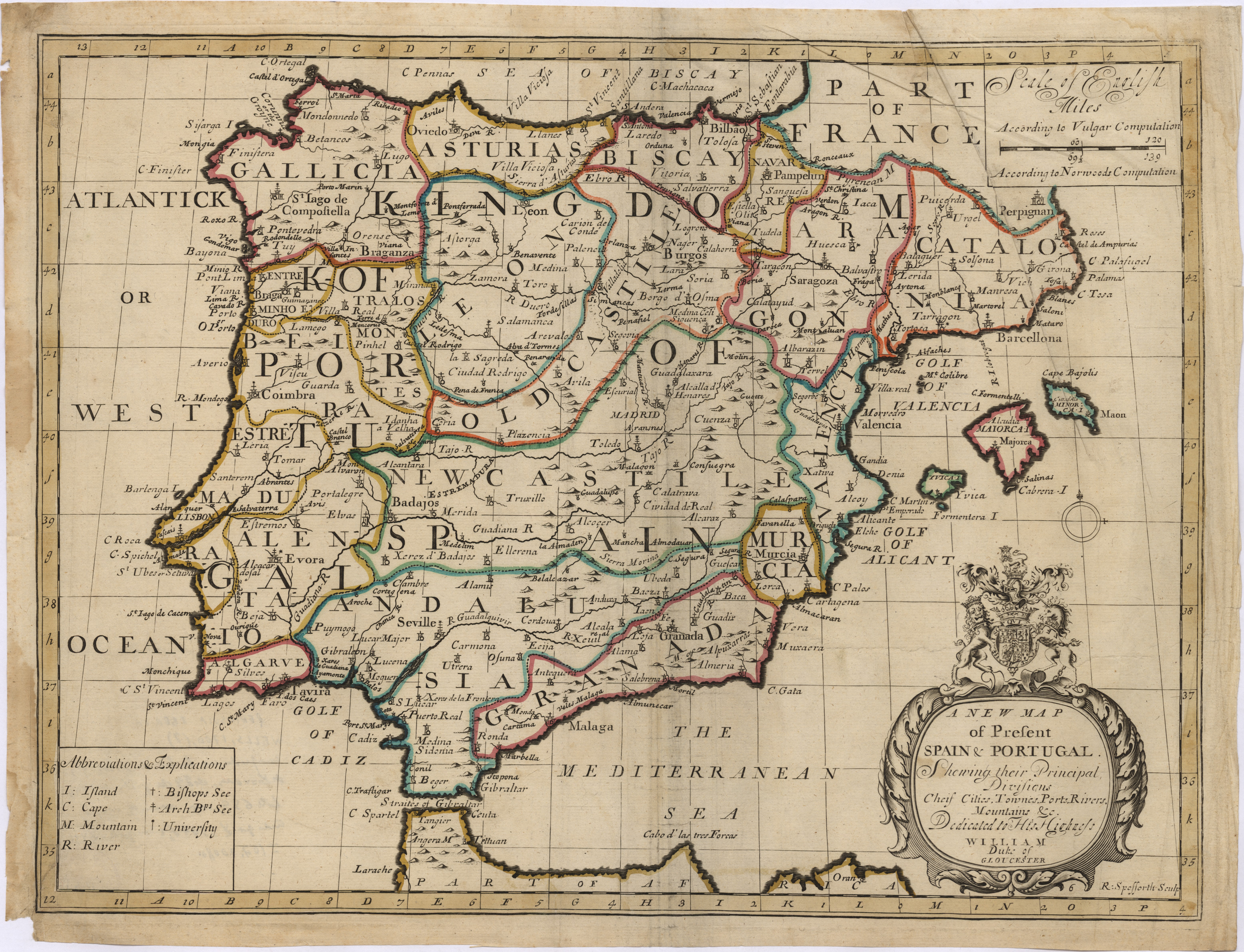 | Wells, Edward, 1667-1727, cartogr., e outro(s)
| A new map of present Spain & Portugal : shewing their principal divisions, cheif cities, townes, rivers, mountains & c. : Dedicated to His Highness William Duke of Gloucester / [Edward Wells]; R. Spofforth sculp . - [London]: [s.n.], 1700 . - 1 mapa | Wells, Edward, 1667-1727, cartogr.; Spofforth, Robert, 16---17--, grav. aguaf. | Entidade: UC | Ver na fonte | Cópia digital | Link persistente deste registo: http://id.bnportugal.gov.pt/bib/rnod/319138 |
| |
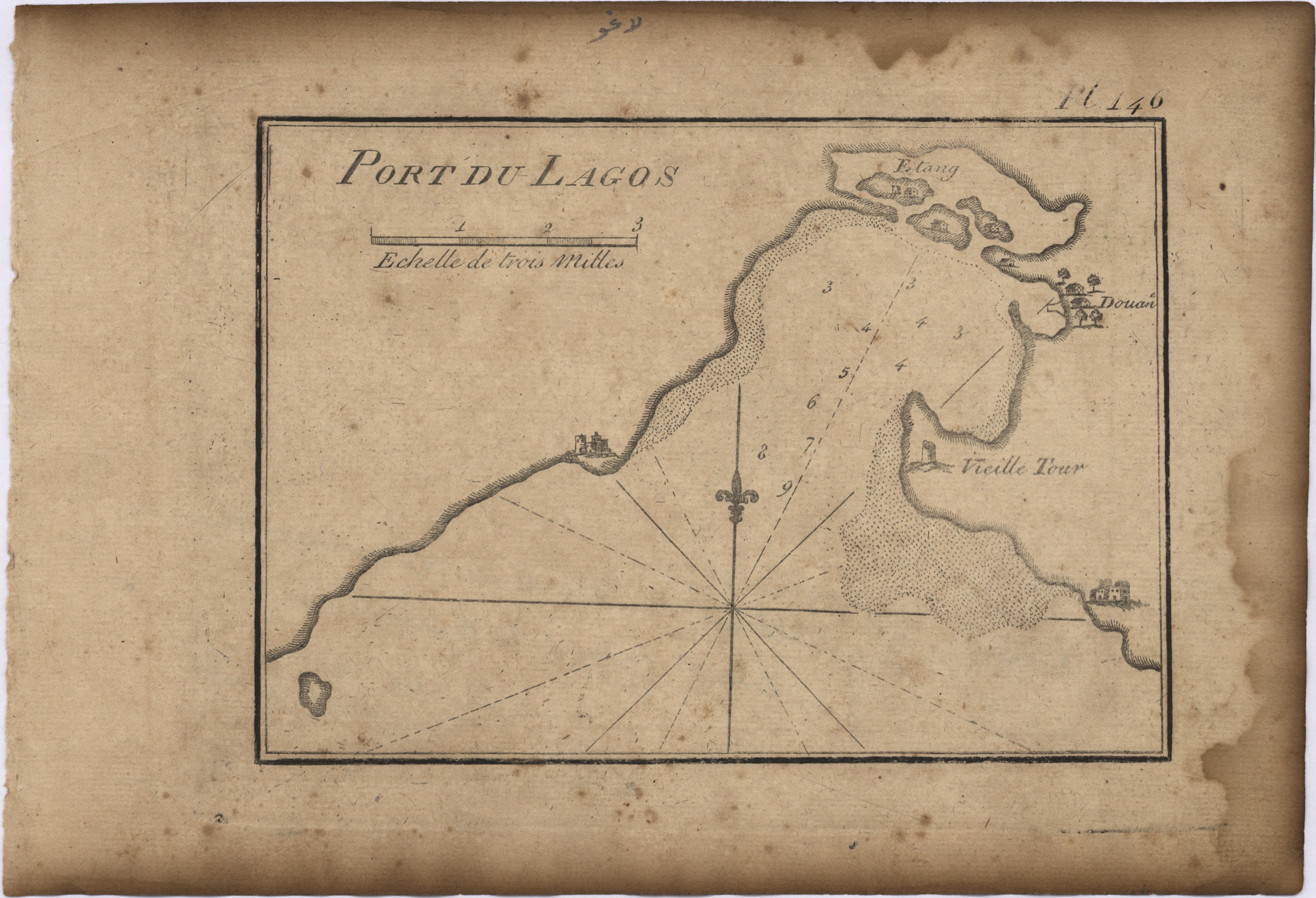 | Roux, Joseph, cartogr.
| Port du Lagos / [Joseph Roux] . - [Livorne]: [Joseph Gamba], [1833?] . - 1 mapa | Roux, Joseph, cartogr. | Entidade: UC | Ver na fonte | Cópia digital | Link persistente deste registo: http://id.bnportugal.gov.pt/bib/rnod/319139 |
| |
 | | |