 | Lopez de Vargas Machuca, Tomás, 1730-1802, cartogr., e outro(s)
| Mapa general del reyno de Portugal : comprehende sus provincias, corregimientos, oidorias, proveedurias, concejos, cotos, &c. : dedicado al ilustrisimo señor Don Pedro Rodriguez Campomanes, caballero de la distinguida orden de Carlos III, del Consejo y Camara de S.M. director de la Real Academia de la Historia &c. / por Don Tomás Lopez . - Madrid: [s.n.], [posterior a 1778] . - 1 mapa | Lopez de Vargas Machuca, Tomás, 1730-1802, cartogr.; Rodríguez Campomanes, Pedro, 1723-1803, dedicado a | Entidade: UC | Ver na fonte | Cópia digital | Link persistente deste registo: http://id.bnportugal.gov.pt/bib/rnod/319159 |
|  |
 | | |
 | Carpinetti, João Silvério, 1740?-1803, e outro(s)
| Mappas das provincias de Portugal novamente abertos, e estampados em Lisboa : com huma illustraçaõ, em que se dá huma breve noticia da Geografia, ensina-se o modo de usar dos Mappas, explicaõ-se os sers caracteres, e se poem huma breve, mas curiosa noticia do nosso Reino, Provincias, Cidades, e Villas mais principaes delle. : offerecidos ao illustrissimo e excellentissimo Senhor Conde de Oeyras, do Conselho de sua Magestade, e seu secretario de Estado dos Negocios do Reino Etc. Etc. Etc. / porJoäo Silvério Carpinetti Lisbonense . - Lisboa: Francisco Manoel, impressor de estampas, às portas de Santo Antão, [1762] . - [6] p., 7 mapas | Carpinetti, João Silvério, 1740?-1803; Pombal, Marquês de, 1699-1782, dedicado a; Pires, Francisco Manuel, ed. com. | Entidade: UC | Ver na fonte | Cópia digital | Link persistente deste registo: http://id.bnportugal.gov.pt/bib/rnod/319156 |
| |
 | Weiland, Carl Ferdinand
| Spanien und Portugal / entworfen und gezeichnet von C. F. Weiland. . - Weimar: Geographisches Institut, 1822 . - 1 mapa em caixa | Weiland, Carl Ferdinand | Entidade: UC | Ver na fonte | Cópia digital | Link persistente deste registo: http://id.bnportugal.gov.pt/bib/rnod/319154 |
| |
 | | |
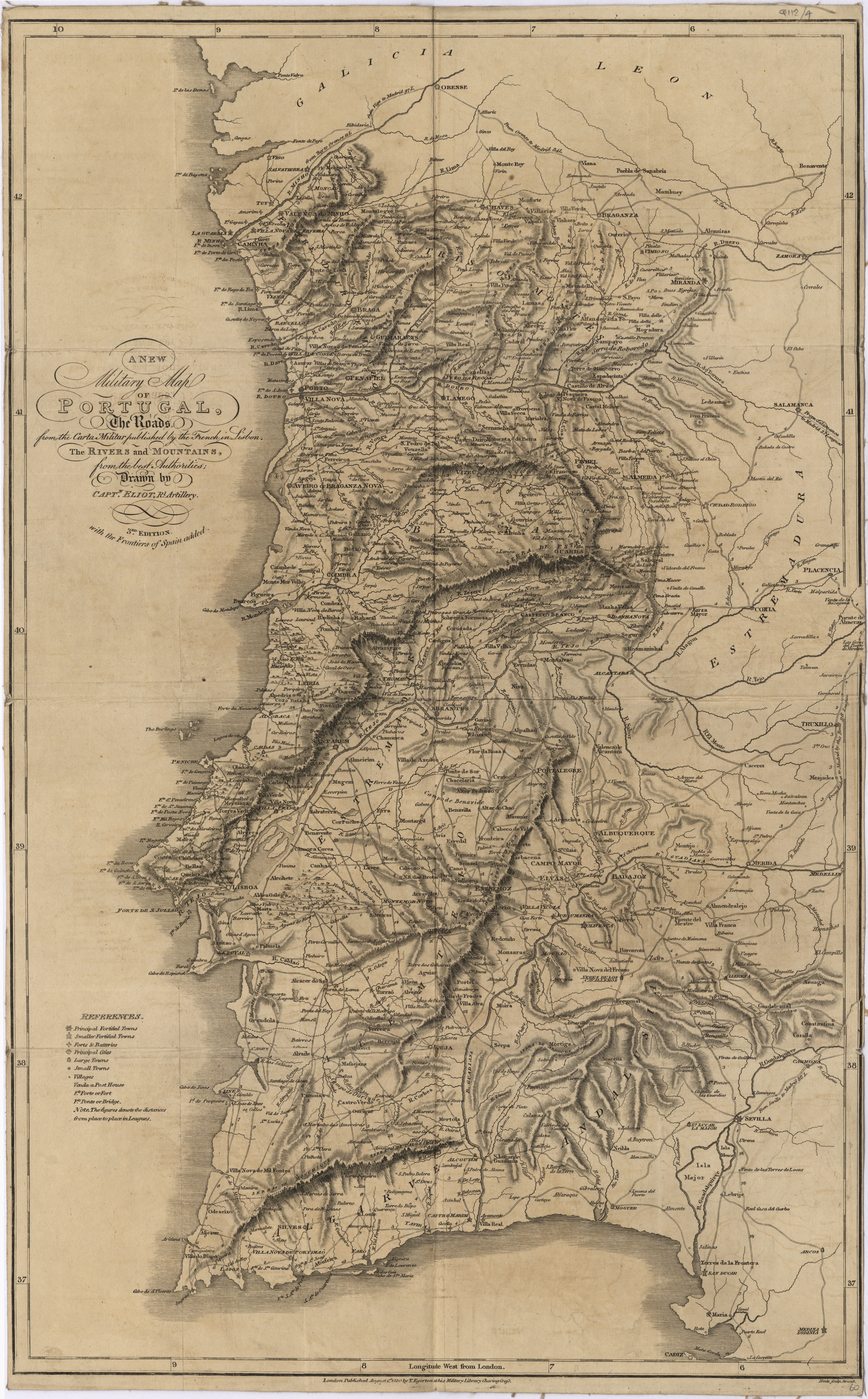 | Elliott, Wm, Capt., fl. 1810-1820, cartogr., e outro(s)
| A new military map of Portugal : the roads from the Carta Militar published by the french in Lisbon : the rivers and mountains from the last Authorities / drawn by Capt.n Eliot, Rl. Artillery; Neele sculp Strand . - 3rd. Edition, with the frontiers of Spain added. . - London: published by T. Egerton at his Military Library Charing Cross, 1810 . - 1 mapa em caixa | Elliott, Wm, Capt., fl. 1810-1820, cartogr.; Neele, Samuel John, 1758-1824, grav. aguaf.; Egerton, T., ed. com. | Entidade: UC | Ver na fonte | Cópia digital | Link persistente deste registo: http://id.bnportugal.gov.pt/bib/rnod/319152 |
| |
 | Carta topographica da cidade de Lisboa
 : reduzida da que foi levantada na escala 1:1 000 em 1856 a 1858 / sob a direcção do general Filippe Folque . - [S.l.]: [s.n.], 1882 . - 1 mapa | Folque, Filipe, 1800-1874, ed. lit. | Entidade: UC | Ver na fonte | Cópia digital | Link persistente deste registo: http://id.bnportugal.gov.pt/bib/rnod/319151 |
| |
 | Nantiat, Jasper, cartogr., e outro(s)
| A new map of Spain and Portugal : exhibiting the chains of mountains with their passes, the principal & cross roads, with other details requisite for the intelligence of Military Operations / compiled by Jaspar Nantiat . - London: published by W. Faden geographer to His Majesty & to His Royal Highness the prince of Wales, Charing cross Jan. 1st 1810 . - 1 mapa em 4 f. em caixa | Nantiat, Jasper, cartogr.; Faden, William, 1749{u2013}1836, ed. com. | Entidade: UC | Ver na fonte | Cópia digital | Link persistente deste registo: http://id.bnportugal.gov.pt/bib/rnod/319150 |
| |
 | Chapman, William, e outro(s)
| A topographical chart of the entrance of the river Tagus, describing the coast from Cape Roca to Sacavem ; with the harbour and environs of Lisbon. The nautical part is from a survey taken in 1806 by W. Chapman, Master of the Royal Navy; and approved by the Chart Committee of the Admiralty. The interior and line of the coast are drawn from survays made by officers of the Quarter Master General's Department . - London: published by W. Faden geographer to His Majesty & to His Royal Highness the prince of Wales, Charing cross Jan. 1st 1810 . - 1 mapa em caixa | Chapman, William; Faden, William, 1749{u2013}1836, ed. com. | Entidade: UC | Ver na fonte | Cópia digital | Link persistente deste registo: http://id.bnportugal.gov.pt/bib/rnod/319149 |
| |